Table of Contents
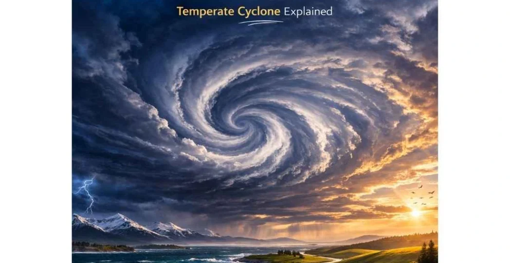
ToggleA Temperate Cyclone is a low-pressure system that develops in the mid-latitudes (35° to 65° in both hemispheres), where warm subtropical air masses meet cold polar air masses. Unlike their tropical counterparts, these systems are driven by frontogenesis and the interaction of contrasting air masses.
Characteristics of Temperate Cyclones
For the UPSC Prelims, it is vital to distinguish these from Tropical Cyclones:
- Origin: They originate in the mid-latitude zone where Polar Fronts are formed.
- Shape: They are typically inverted V-shaped or elliptical.
- Size: They cover a vast area, sometimes spanning 1,500 to 3,000 km, much larger than tropical cyclones.
- Movement: They move from West to East under the influence of the Westerlies.
- Velocity: The wind speed is generally lower (30–50 km/h) compared to the violent speeds of tropical cyclones, but they last much longer (several days to weeks).
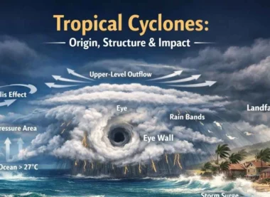
- Structure: They do not have a calm “eye”; instead, they are characterized by distinct Warm Fronts and Cold Fronts.
The Life Cycle of a Temperate Cyclone: Polar Front Theory
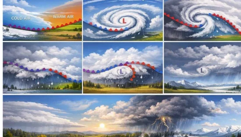
The most widely accepted explanation for the birth of a temperate cyclone is the Polar Front Theory (or Norwegian School of Meteorology). The evolution occurs in six distinct stages:
Stage 1: Stationary Stage
- A Stationary Front exists between cold polar air (Easterlies) and warm subtropical air (Westerlies). The two air masses flow parallel to each other in opposite directions.
Stage 2: Incipient Stage (Frontogenesis)
- A disturbance (often caused by a Jet Stream overhead) creates a wave in the front. Warm air begins to push into the cold air territory, and cold air pushes into the warm air territory.
Stage 3: Mature Stage
- The cyclone is fully developed. A distinct Warm Front precedes the system, followed by a Cold Front. The area between the two is known as the Warm Sector.
Stage 4: Beginning of Occlusion
- The Cold Front moves faster than the Warm Front. Eventually, the cold air begins to overtake the warm air, lifting the warm sector off the ground.
Stage 5: Occluded Stage
- The warm air is completely lifted (buoyed up) from the surface. The meeting of the two cold air masses (polar and modified) creates an Occluded Front.
Stage 6: Dissipation Stage
- The moisture and temperature contrast are lost. The low-pressure center weakens, and the cyclone finally dies out (Frontolysis).
Weather Patterns Associated with Temperate Cyclones
As a temperate cyclone passes over a location, a sequence of weather changes occurs:
- Arrival of the Warm Front: The sky becomes overcast with Cirrus clouds, followed by Altostratus and Nimbostratus. This results in light to moderate prolonged rainfall over a large area.
- The Warm Sector: After the warm front passes, the temperature rises, the sky clears temporarily, and the weather becomes humid.
- Arrival of the Cold Front: Temperature drops sharply. Heavy cumulonimbus clouds form, leading to intense thunderstorms, heavy rain, or snowfall (in winter), often accompanied by squalls.
- Post-Cold Front: The sky clears, the temperature remains low, and high-pressure conditions return.
Comparison: Temperate vs. Tropical Cyclones
This is a favorite topic for UPSC Mains.
Significance for India: Western Disturbances
During the winter months, the Sub-tropical Westerly Jet Stream brings temperate cyclones from the Mediterranean Sea towards South Asia.
- Impact: These are known as Western Disturbances.
- Agriculture: They bring much-needed winter rainfall to the plains of Northwest India and heavy snowfall to the Himalayas, which is crucial for the Rabi Crops (especially wheat).
- Climate: They cause a sudden dip in temperature (Cold Wave) across North India.
UPSC Prelims: PYQs & Practice Questions
Previous Year Questions (PYQs)
1. The jet aircraft fly very easily and smoothly in the lower stratosphere. What could be the appropriate explanation? (2011)
Q:
1. There are no clouds or water vapour in the lower stratosphere.
2. There are no vertical winds in the lower stratosphere.
Which of the statements given above is/are correct in this context?
(a) 1 only
(b) 2 only
(c) Both 1 and 2
(d) Neither 1 nor 2
Answer: (c) Both 1 and 2
Explanation: The lower stratosphere is comparatively dry and stable, with very little moisture (hence minimal clouds). It also has weak vertical mixing/turbulence compared to the troposphere, so aircraft experience smoother conditions. This stability helps jets avoid the convection and weather-related turbulence common in the lower atmosphere.
2. "Western Disturbances", which cause winter rain in India, originate in which of the following regions? (Generic UPSC Theme/Direct Fact)
Q:
(a) Arabian Sea
(b) Bay of Bengal
(c) Mediterranean Sea
(d) Caspian Sea
Answer: (c) Mediterranean Sea
Explanation: Western Disturbances are extra-tropical systems that typically originate over the Mediterranean region. They travel eastward with the westerlies and are steered towards the Indian subcontinent by upper-air westerly flow, bringing winter rain to northwest India and snowfall to the western Himalayas.
Practice Questions (Prelims)
Question 1
Q: Consider the following statements regarding the “Occluded Front” in a temperate cyclone:
1. It forms when a cold front overtakes a warm front.
2. It signifies the mature stage and the beginning of the dissipation of the cyclone.
3. The warm air mass is completely lifted off the ground surface.
Which of the statements given above are correct?
(a) 1 and 2 only
(b) 2 and 3 only
(c) 1 and 3 only
(d) 1, 2, and 3
Answer: (d) 1, 2, and 3
Explanation: An occlusion occurs when the faster-moving cold front catches up with the warm front, forcing the warm air to rise. This marks the mature stage and signals the start of weakening because the warm air is lifted away from the surface. With reduced surface temperature contrast, the cyclone gradually loses its energy and dissipates.
Question 2
Q: Which type of clouds are most commonly associated with the arrival of a “Warm Front” in a temperate cyclone?
(a) Cumulonimbus
(b) Cirrus and Stratus
(c) Altocumulus
(d) Noctilucent
Answer: (b) Cirrus and Stratus
Explanation: A warm front has a gentle slope where warm air glides over colder air, producing layered (stratiform) clouds. Typically, clouds appear in sequence: Cirrus → Cirrostratus → Altostratus → Nimbostratus, often resulting in steady and light rainfall.
UPSC Mains – Previous Year & Practice Questions
Previous Year Questions (Mains)
Western Disturbances & North Indian Weather (General Theme)
Question: “How do the ‘Western Disturbances’ affect the prevailing weather conditions in North India?”
Focus: Discuss the arrival of clouds, increase in night temperature, and the importance of precipitation for Rabi crops.
Tropical Cyclones vs Temperate Cyclones (2013/Standard Practice)
Question: “Compare the origin and characteristics of Tropical Cyclones and Temperate Cyclones.”
Focus: Frontal vs. thermal origin, westward vs. eastward movement, and the presence/absence of an ‘Eye’.
Life Cycle of a Temperate Cyclone (Polar Front Theory)
Question: “Describe the life cycle of a temperate cyclone as explained by the Polar Front Theory.”
Focus: Step-by-step evolution from a stationary front to occlusion.
Weather Changes During Cold Front Passage (General Theme)
Question: “Explain the weather changes associated with the passage of a cold front.”
Focus: Sharp temperature drop, pressure rise, and intense but short-lived thunderstorms.
Jet Streams & Extra-Tropical Cyclones (General Theme)
Question: “Discuss the role of Jet Streams in the formation and movement of extra-tropical cyclones.”
Focus: Upper-air divergence and the steering of surface systems.
Mains Practice Questions
Temperate Cyclones & Northwest India’s Agriculture
Question: “Analyze the socio-economic significance of temperate cyclones for the agricultural landscape of Northwest India.” (250 words)
Why Temperate Cyclones Are Larger & Longer-Lived
Question: “Why do temperate cyclones cover a larger area and last longer than tropical cyclones? Explain the underlying physical mechanisms.” (250 words)
Arctic Warming & Mid-Latitude Cyclones
Question: “Examine the impact of Arctic warming on the frequency and path of mid-latitude cyclonic systems.” (250 words)
Temperate Cyclones: Origin, Life Cycle - FAQs
Do temperate cyclones have an 'Eye' like tropical cyclones?
No. Temperate cyclones do not have a calm, central eye. Instead, they have a low-pressure center where fronts converge, and the entire system is characterized by cloudiness and precipitation.
Why do temperate cyclones move from West to East?
They are located in the mid-latitudes (35°-65°), which is the domain of the Westerlies. These permanent planetary winds steer the cyclonic systems eastward.
Can temperate cyclones form over land?
Yes. Unlike tropical cyclones which need the warm ocean’s latent heat, temperate cyclones form due to temperature contrasts between air masses. They can develop over both land and sea.
What is 'Frontogenesis'?
It is the process of the creation or regeneration of a front. In the context of temperate cyclones, it is the initial stage where a boundary between cold and warm air begins to deform into a wave.
Why is the rainfall from a Warm Front longer-lasting than a Cold Front?
The slope of a Warm Front is very gradual (1:100 to 1:400). Warm air rises slowly over a vast area, creating thick stratus clouds. In contrast, a Cold Front is steep (1:50 to 1:100), forcing air up violently and creating intense but narrow bands of rain.