Table of Contents
ToggleA Tropical Cyclone is a rapid, rotating storm system characterized by a low-pressure center, a strong pressure gradient, and a spiral arrangement of thunderstorms that produce heavy rain and squalls. They are among the most destructive natural disasters on Earth.
Conditions for the Formation of Tropical Cyclones
Unlike temperate cyclones, tropical cyclones are purely thermal in origin. They require specific environmental “triggers” to develop:
Warm Sea Surface Temperature (SST): A constant supply of warm water with temperatures higher than 27°C is essential. This provides the latent heat of condensation, which is the “fuel” for the cyclone.
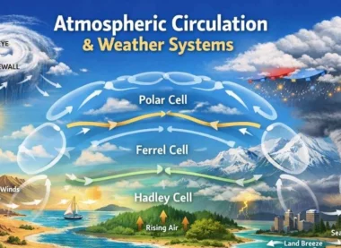
Coriolis Force: There must be enough Coriolis force to create a cyclonic vortex (rotation). This is why cyclones do not form within 0°–5° of the Equator.
Vertical Wind Shear: There should be small variations in the vertical wind speed. High vertical wind shear “cuts off” the top of the storm, preventing it from organizing.
Pre-existing Weak Low-Pressure Area: A pre-existing weak low-pressure area or a low-level-cyclonic circulation (like the ITCZ) acts as a seed for the cyclone.
Upper-Level Divergence: Above the sea-level system, there must be a mechanism to pump out the rising air, allowing more air to be sucked in from below.
Mechanism of Origin and Development
The energy of a tropical cyclone comes from the latent heat released during the condensation of water vapor.
- Step 1: Evaporation and Convection: Warm sea water evaporates, and the moist air rises.
- Step 2: Latent Heat Release: As the air rises and cools, the water vapor condenses into clouds, releasing latent heat. This heat warms the surrounding air, making it lighter and causing it to rise further.
- Step 3: Pressure Drop: This continuous rising of air creates a very deep low pressure at the surface.
- Step 4: Cyclonic Rotation: Winds rush into this low-pressure center and are deflected by the Coriolis Force, creating the characteristic spiral.
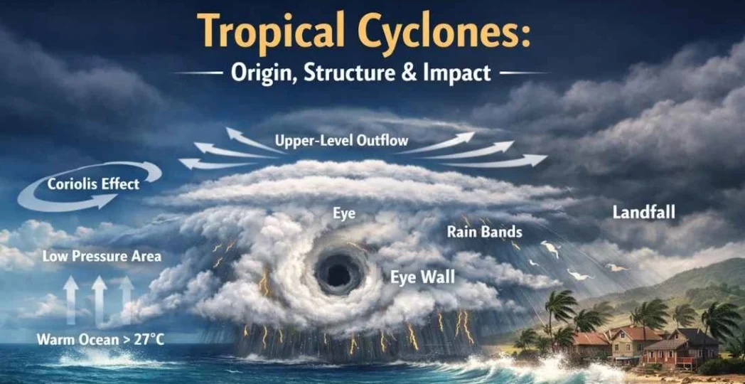
Structure of a Tropical Cyclone
A mature tropical cyclone is a highly organized system with distinct parts:
A. The Eye
The center of a mature tropical cyclone is called the Eye. It is a region of calm air, falling pressure, and surprisingly, clear skies with little to no rain. It is a zone of subsiding air (sinking air)
B. The Eye Wall
Surrounding the eye is the Eye Wall, where the most violent winds and heaviest rains occur. Here, the air reaches its maximum velocity and spirals upward to the Tropopause.
C. Spiral Bands (Rain Bands)
Radiating outward from the eye wall are bands of cumulonimbus clouds that produce heavy bursts of rain and wind.
Regional Nomenclature
Tropical cyclones are known by different names depending on the ocean basin in which they form:
| Region | Local Name |
| Indian Ocean | Cyclones |
| Atlantic Ocean | Hurricanes |
| Western Pacific & South China Sea | Typhoons |
| Western Australia | Willy-willies |
Why are Cyclones more frequent in the Bay of Bengal than the Arabian Sea?
This is a frequent UPSC Mains question. The reasons are:
- Higher Temperature: The Bay of Bengal is warmer than the Arabian Sea, providing more energy.
- Salinity: The Bay of Bengal receives high freshwater discharge from rivers (Ganga, Brahmaputra), which stays on the surface and stays warm, unlike the saltier, denser water of the Arabian Sea that mixes more easily.
- Remnant Cyclones: Many cyclones in the Bay of Bengal are actually remnants of Typhoons from the Pacific that cross the Malay Peninsula and re-intensify.
- Shape of Coastline: The “funnel” shape of the Bay of Bengal increases the Storm Surge height.
Impact and Destruction
- Storm Surge: This is the most lethal aspect. It is an abnormal rise of sea water caused by the storm’s low pressure and strong winds, which pushes water onto the land, causing massive coastal flooding.
- High-Speed Winds: Can destroy infrastructure, uproot trees, and disrupt telecommunications.
- Torrential Rainfall: Leads to inland flooding and landslides in hilly terrains.
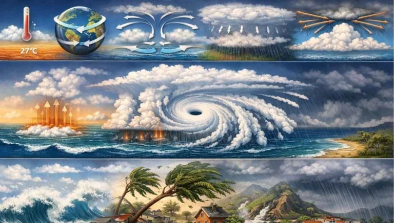
Landfall of a Cyclone
The moment the eye of a cyclone crosses the coastline is called Landfall. Once it reaches land, the moisture supply (its fuel) is cut off, and the cyclone begins to dissipate due to increased surface friction.
UPSC Prelims: PYQs & Practice Questions
Previous Year Questions (PYQs)
1. Consider the following statements (2020)
Q:
1. Jet streams occur in the Northern Hemisphere only.
2. Only some cyclones develop an eye.
3. The temperature inside the eye of a cyclone is nearly 10°C lesser than that of the surroundings.
Which of the statements given above is/are correct?
(a) 1 only
(b) 2 and 3 only
(c) 2 only
(d) 1 and 3 only
Answer: (c) 2 only
Explanation: Statement 1 is wrong; jet streams occur in both hemispheres. Statement 3 is wrong; the eye is a zone of subsiding air which warms adiabatically, making the eye temperature warmer (not cooler) than the surroundings. Statement 2 is correct; only mature, intense tropical cyclones develop a well-defined eye.
2. In the South Atlantic and South-Eastern Pacific regions in tropical latitudes, cyclones do not originate. What is the reason? (2015)
Q: In the South Atlantic and South-Eastern Pacific regions in tropical latitudes, cyclones do not originate. What is the reason?
(a) Sea surface temperatures are low
(b) Inter-tropical Convergence Zone (ITCZ) seldom occurs
(c) Coriolis force is too weak
(d) Absence of land in those regions
Answer: (b) Inter-tropical Convergence Zone (ITCZ) seldom occurs
Explanation: While SST is a factor, the primary dynamic reason cited by NCERT and the IMD is that the ITCZ rarely shifts into these specific regions, preventing the necessary low-level convergence required to trigger a cyclone.
Practice Questions (Prelims)
Question 1
Q: Which of the following conditions is/are NOT favorable for the formation of a Tropical Cyclone?
1. Sea surface temperature lower than 27°C.
2. Large variations in the vertical wind speed.
3. Presence of the Coriolis force.
Which of the statements given above is/are correct?
(a) 1 and 2 only
(b) 2 and 3 only
(c) 1 and 3 only
(d) 1, 2, and 3
Answer: (a) 1 and 2 only
Explanation: For a cyclone to form, sea surface temperature should be higher than 27°C and vertical wind shear should be low (small variation). Coriolis force is a required favorable condition for cyclone formation.
Question 2
Q: With reference to the “Eye” of a tropical cyclone, consider the following:
1. It is a region of intense low pressure.
2. It is characterized by strong winds and heavy rainfall.
3. It is a zone of subsiding (sinking) air.
Which of the statements given above is/are correct?
(a) 1 and 2 only
(b) 1 and 3 only
(c) 3 only
(d) 1, 2, and 3
Answer: (b) 1 and 3 only
Explanation: The eye is generally calm with little to no rain; the violent weather (strong winds and heavy rainfall) occurs in the eyewall. The eye is a zone of subsiding air and is associated with very low pressure.
UPSC Mains – Previous Year & Practice Questions
Previous Year Questions (Mains)
Tropical Cyclone Basins (2014)
Question: “Tropical cyclones are largely confined to the South China Sea, Bay of Bengal and Gulf of Mexico. Why?” (2014)
Concept: Focus on the thermal energy (SST) and the presence of the ITCZ/Coriolis force in these specific basins.
Cyclone Fani: Path & Intensity Variations (Theme from 2019)
Question: “The recent cyclone ‘Fani’ was different from previous ones in terms of its path and intensity. Discuss the factors responsible for such variations.” (Theme from 2019)
Concept: Discuss warming of oceans, recurving paths, and the role of upper-air circulation.
Global Warming & North Indian Ocean Cyclones (General Theme)
Question: “Assess the impact of Global Warming on the frequency and intensity of tropical cyclones in the North Indian Ocean.” (General Theme)
Concept: Linking climate change to higher SST and the rapid intensification of storms.
Tropical vs Extra-tropical Cyclones (Standard Practice)
Question: “Compare the structure and weather associated with Tropical Cyclones and Extra-tropical Cyclones.” (Standard Practice)
Concept: Thermal vs frontal origin, size, and duration.
Role of IMD in Cyclone Disaster Mitigation (General Theme)
Question: “Discuss the role of the India Meteorological Department (IMD) in disaster mitigation during cyclonic events.” (General Theme)
Concept: Early Warning Systems (EWS), satellite tracking, and color-coded alerts.
Mains Practice Questions
Arabian Sea: Rise in Severe Cyclonic Storms
Question: Explain why the Arabian Sea is witnessing an increasing number of severe cyclonic storms in recent years compared to the historical average. (250 words)
Storm Surge & India’s East Coast Vulnerability
Question: Analyze the concept of ‘Storm Surge’ and why the East Coast of India is more vulnerable to its devastating effects than the West Coast. (250 words)
Odisha Model of Cyclone Management & DRR
Question: Evaluate the effectiveness of the ‘Odisha Model’ of cyclone management in the context of Disaster Risk Reduction (DRR). (250 words)
Tropical Cyclones: Origin, Structure, and Impact - FAQs
What is 'Landfall' of a cyclone?
Landfall is the event where the eye of the cyclone moves over the coastline. It is usually the moment of highest impact, followed by the storm weakening as its moisture source is cut off.
Why do cyclones dissipate over land?
Two reasons: 1) The supply of latent heat from the warm ocean is cut off. 2) Increased surface friction over land dissipates the wind energy.
What is the Saffir-Simpson Scale?
It is a 1 to 5 rating based on a cyclone’s sustained wind speed. It estimates potential property damage. (In India, the IMD uses a different classification: CS, SCS, VSCS, ESCS, and SuCS).
What is the difference between a Hurricane, Typhoon, and Cyclone?
There is no physical difference; they are the same weather phenomenon. The name changes based on location: Hurricanes (Atlantic/Northeast Pacific), Typhoons (Northwest Pacific), and Cyclones (Indian Ocean/South Pacific).
Why are there no cyclones at the Equator?
The Coriolis force is zero at the equator. Without Coriolis force, the air cannot be deflected into a spiral, so it simply flows straight into the low-pressure center and fills it, preventing a storm from organizing.