Table of Contents
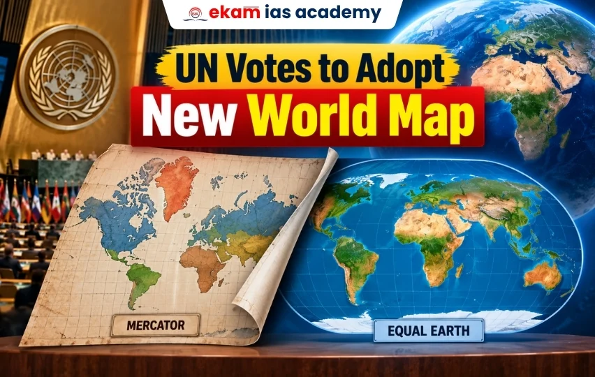
ToggleThe United Nations General Assembly (UNGA) has adopted a resolution supporting the use of a new world map that represents the actual size of continents more accurately, with particular emphasis on correcting the long-standing underrepresentation of Africa. The move encourages the use of modern map projections, such as the Equal Earth projection, instead of relying solely on the traditional Mercator map.
UN Resolution on the New World Map
The resolution, titled “Correct the Map,” was introduced by Togo on behalf of the African Union (AU). It received overwhelming support, with 164 countries voting in favour, while the United States opposed the resolution and six nations abstained.
Although the resolution is non-binding, it is expected to encourage governments, educational institutions, publishers and digital mapping platforms to gradually adopt map projections that provide a more accurate depiction of the Earth’s land areas.
Why Was a New Map Needed?
The proposal stems from the limitations of the Mercator projection, developed by Gerardus Mercator in 1569. While the Mercator map remains highly effective for maritime navigation because it preserves direction, it significantly distorts the size of landmasses.
Regions located near the poles appear much larger than they actually are, whereas countries and continents near the Equator appear comparatively smaller. A common example is Greenland, which appears almost as large as Africa on the Mercator map, despite Africa being nearly 14 times larger in reality.
Supporters argue that such distortions have influenced global perceptions of Africa’s geographical size, natural resources and geopolitical importance for centuries.
Equal Earth Projection
The UN resolution promotes the Equal Earth projection, introduced in 2018 by an international group of cartographers. Unlike the Mercator projection, Equal Earth preserves the relative size of continents more accurately while still offering an aesthetically balanced world map.
The African Union has already adopted this projection, describing it as a fairer representation of Africa and other equatorial regions. However, the Mercator projection will continue to be used for specialised purposes such as navigation, where preserving direction remains essential.
Significance of the Decision
The adoption of the resolution could influence the preparation of school textbooks, educational materials, government publications, atlases and digital mapping platforms worldwide.
Supporters view the initiative as more than a cartographic adjustment. They believe maps shape public understanding of geography and global power, making accurate representation important for education and international awareness.
Countries such as France have also announced plans to move towards area-preserving map projections for educational purposes. Meanwhile, the United States argued that the General Assembly should prioritise other international issues.
Conclusion
The UN-backed initiative reflects a growing recognition that maps influence how people perceive the world. By encouraging the use of projections such as Equal Earth, the resolution seeks to present continents in proportions that more closely reflect reality. While it does not replace the Mercator projection for navigation, it promotes a more balanced geographical representation for education, research and public information.


FAQs: UN Adopts New World Map
What is the “Correct the Map” resolution?
It is a non-binding UN General Assembly resolution promoting more accurate world map projections, particularly to address distortions in the representation of Africa and other equatorial regions.
Why is the Mercator projection criticised?
The Mercator projection, developed in 1569, preserves direction and is useful for navigation but significantly distorts the size of landmasses, making areas near the poles appear much larger than they actually are.
What is the Equal Earth projection?
The Equal Earth projection, introduced in 2018, is an area-preserving map projection that represents the relative sizes of continents more accurately than the Mercator projection.
Why is the new map significant for Africa?
Africa is substantially larger than it appears on the Mercator projection. The Equal Earth projection provides a more accurate representation of Africa’s geographical size and its position relative to other continents.
Will the Equal Earth projection completely replace the Mercator projection?
No. The resolution does not eliminate the Mercator projection. Mercator remains useful for maritime navigation, while area-preserving projections such as Equal Earth may be preferred for education, atlases and geographical representation.