Table of Contents
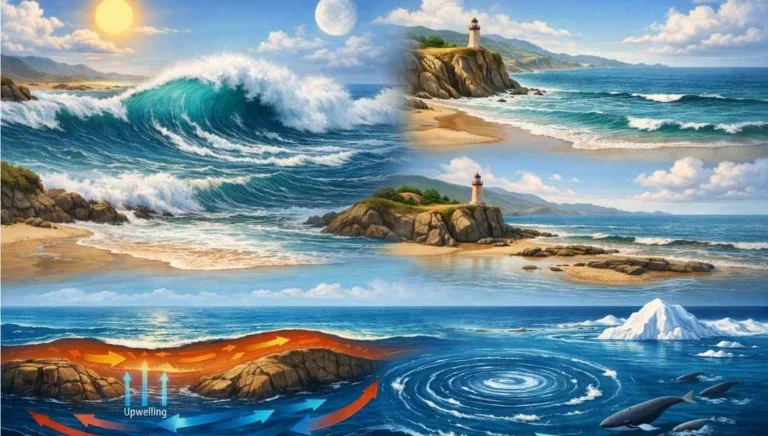
ToggleThe ocean is never still. The movement of its water is categorized into Horizontal Motion (Waves and Currents) and Vertical Motion (Tides and Upwelling/Sinking). These movements are driven by energy from the sun, the gravitational pull of the moon and sun, and the Coriolis Force.
Waves: Energy in Motion
Waves are essentially the energy moving across the ocean surface, not the water itself. While the wave train moves forward, the water particles primarily move in small vertical circles.
Key Characteristics of Waves
- Origin: Most waves are generated by wind blowing over the water surface. The friction between wind and water transfers energy.
- Wave Crest and Trough: The highest point is the Crest; the lowest is the Trough.
- Wave Height: The vertical distance between the crest and the trough.
- Wavelength: The horizontal distance between two consecutive crests or troughs.
- Wave Period: The time interval between two consecutive wave crests passing a fixed point.
- Fetch: The distance over which the wind blows in a single direction without interruption. A larger fetch results in larger waves.
Types of Waves
- Sea Waves: Irregular waves generated by local winds.
- Swell: Long, smooth waves that have traveled far from their place of origin.
- Breakers: When a wave approaches the shore, the bottom of the wave is slowed by friction with the seafloor. The top continues at its speed, causing the wave to “break” or collapse as Surf.
Tides: The Rhythmic Pulse
Tides are the periodical rise and fall of the sea level, usually occurring once or twice a day. They are primarily caused by the gravitational pull of the moon and, to a lesser extent, the sun.
The Mechanism of Tides
Tides result from the interplay of:
- Gravitational Attraction: The moon’s pull creates a “bulge” of water on the side of Earth facing it.
- Centrifugal Force: On the opposite side of Earth, the centrifugal force (due to the Earth-Moon rotation) creates a second bulge.
Classification of Tides
A. Based on Frequency
- Semi-Diurnal Tide: Two high tides and two low tides each day. This is the most common pattern (e.g., Atlantic coasts).
- Diurnal Tide: Only one high tide and one low tide each day (e.g., Gulf of Mexico).
- Mixed Tide: Tides with variations in height; common along the West coast of North America.
B. Based on the Sun, Moon, and Earth Position
Spring Tides: Occur when the Sun, Moon, and Earth are in a straight line (Syzygy). The gravitational pulls combine, leading to the highest high tides and lowest low tides. These happen during Full Moon and New Moon.
Neap Tides: Occur when the Sun and Moon are at right angles to each other (Quadrature). Their forces counteract, resulting in the lowest tidal range.
Other Factors: Perigee and Apogee
- Perigee: When the moon is closest to Earth, tidal ranges are higher than average.
- Apogee: When the moon is farthest, tidal ranges are lower.
Significance of Tides
- Navigation: High tides allow large ships to enter shallow harbors (e.g., Kolkata Port on the Hooghly river).
- Desilting: Tides help wash away sediments from river estuaries.
- Tidal Energy: Harnessing the movement of water to generate electricity (e.g., Gulf of Khambhat).
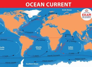
Ocean Currents: The Global Conveyor Belt
Ocean Currents are like vast rivers flowing in the ocean, representing a continuous, directed movement of seawater. They constitute about 10% of the ocean’s water as Surface Currents and 90% as Deep Water Currents.
Factors Influencing Ocean Currents
Primary Forces (Initiate Movement)
- Heating by Solar Energy: Water expands near the equator, creating a slight gradient that causes water to flow poleward.
- Wind: The Trade Winds and Westerlies drag the surface water.
- Gravity: Pulls water down gradients.
- Coriolis Force: Deflects currents to the right in the Northern Hemisphere and to the left in the Southern Hemisphere (Ferrel’s Law).
Secondary Forces (Modify Flow)
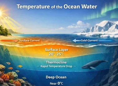
- Temperature Difference: Cold water is denser and sinks; warm water is lighter and rises.
- Salinity: Higher salinity makes water denser, causing it to sink.
- Configuration of Coastlines: Landmasses obstruct and redirect current flow.
Types of Ocean Currents
- Surface Currents: Upper 400m of the ocean.
- Deep Water Currents: Driven by density and temperature (Thermohaline Circulation).
- Warm Currents: Flow from low latitudes to high latitudes (e.g., Gulf Stream, Kuroshio).
- Cold Currents: Flow from high latitudes to low latitudes (e.g., Labrador, Canary, Humboldt/Peru).
Oceanic Gyres
A Gyre is a large system of circulating ocean currents. There are five major gyres: North Atlantic, South Atlantic, North Pacific, South Pacific, and Indian Ocean.
- Sargasso Sea: A unique area in the North Atlantic trapped within a gyre, characterized by calm water and floating seaweed.
Global Distribution and Impact
Major Currents of the Pacific
- Kuroshio (Warm) and Oyashio (Cold): Their meeting point near Japan creates a rich fishing ground but also thick fog.
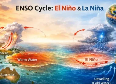
- Humboldt/Peru Current (Cold): Influences the El Niño phenomenon.
Major Currents of the Atlantic
- Gulf Stream (Warm): Keeps the ports of North-Western Europe ice-free in winter (e.g., London, Bergen).
- Benguela Current (Cold): Contributes to the aridity of the Namib Desert.
Impact on Climate
- Temperature Regulation: Currents act as a heat transfer mechanism from the equator to the poles.
- Rainfall: Warm currents lead to evaporation and rain in coastal areas; cold currents lead to stable atmospheric conditions and deserts (e.g., Atacama, Namib).


UPSC Prelims: PYQs & Practice Questions
Previous Year Questions (PYQs)
1. Consider the following factors: (2012)
Q:
1. Rotation of the Earth
2. Air pressure and wind
3. Density of ocean water
4. Revolution of the Earth
Which of the above factors influence the ocean currents?
(a) 1 and 2 only
(b) 1, 2, and 3 only
(c) 1 and 4 only
(d) 2, 3, and 4 only
Answer: (b) 1, 2, and 3 only
Explanation: Rotation causes the Coriolis force, wind provides surface drag, and density (driven by temperature/salinity) causes vertical thermohaline circulation. Revolution (Earth moving around the Sun) dictates seasons but does not directly move ocean water.
2. Which of the following is a cold current? (General UPSC Theme)
Q:
(a) Brazil Current
(b) Gulf Stream
(c) Kuroshio Current
(d) Canary Current
Answer: (d) Canary Current
Explanation: The Canary Current flows from the North Atlantic toward the Equator along the coast of Africa, bringing cold water. The others are warm currents flowing from the tropics toward the poles.
Practice Questions (Prelims)
Question 1
Q: With reference to Spring Tides, consider the following statements:
1. They occur when the Sun, Moon, and Earth are in a straight line.
2. They only occur during the New Moon.
3. The tidal range during a Spring Tide is the maximum.
Which of the statements given above is/are correct?
(a) 1 and 2 only
(b) 2 and 3 only
(c) 1 and 3 only
(d) 1, 2, and 3
Answer: (c) 1 and 3 only
Explanation: Spring tides occur during both the New Moon and the Full Moon (syzygy), when the Sun, Moon, and Earth align. Hence, statement 2 is incorrect, while statements 1 and 3 are correct.
Question 2
Q: The Sargasso Sea is unique because it:
(a) Is the only sea with no land boundaries.
(b) Has the lowest salinity in the Atlantic Ocean.
(c) Is a region of intense cyclonic activity.
(d) Is located at the meeting point of two cold currents.
Answer: (a)
Explanation: The Sargasso Sea is defined by four currents—Gulf Stream, North Atlantic Current, Canary Current, and North Atlantic Equatorial Current—which form an ocean gyre. This traps a body of water in the middle of the Atlantic with no coastline, making it the only “sea” without land boundaries.
UPSC Mains – Previous Year & Practice Questions
Previous Year Questions (Mains)
Origin of Ocean Currents & Regional Climate (GS Paper I)
Question: “Explain the factors responsible for the origin of ocean currents. How do they influence the regional climate?”
Focus: Discuss primary forces (solar heating, winds, Coriolis) and secondary forces (gravity, density). Use examples like the North Atlantic Drift warming Europe.
Economic Significance of Tides in India (General Theme)
Question: “What are the economic significances of tides in India?”
Focus: Mention tidal energy (Gulf of Kutch), navigation in tidal ports (Kolkata/Kandla), and fishing.
North Atlantic vs North Pacific Current Systems (Optional/GS Theme)
Question: “Compare and contrast the current systems of the North Atlantic and the North Pacific Oceans.”
Focus: Compare Gulf Stream vs Kuroshio, and explain how landmass configuration influences gyre shape and flow patterns.
Thermohaline Circulation & Global Heat Redistribution (General Theme)
Question: “Discuss the concept of ‘Thermohaline Circulation’ and its importance in global heat redistribution.”
Focus: Explain the “global conveyor belt” driven by temperature and salinity differences and its role in climate regulation.
Ocean Water Movement & Coastal Deserts (General Theme)
Question: “How does the movement of ocean water affect the formation of coastal deserts?”
Focus: Link cold currents (e.g., Benguela) to atmospheric stability, low evaporation, suppressed convection, and reduced rainfall.
Mains Practice Questions
Climate Change & AMOC Stability
Question: “Analyze the impact of climate change on the stability of the Atlantic Meridional Overturning Circulation (AMOC).” (250 words)
Tidal Bore: Formation & Indian Examples
Question: “What is a ‘Tidal Bore’? Explain its formation and its presence in Indian river systems.” (250 words)
Coriolis Force, Ekman Spiral & Horizontal Ocean Movement
Question: “Examine the role of the Coriolis force and the Ekman Spiral in the horizontal movement of ocean water.” (250 words)
Movements of Ocean Water: Waves, Tides, and Ocean Currents- FAQs
What is the difference between a wave and a current?
A wave is the movement of energy across the surface; the water particles move mostly in circles. A current is the actual physical movement of water from one location to another, like a river in the ocean.
Why are the highest tides found in the Bay of Fundy?
This is due to tidal resonance. The shape of the bay and its depth cause the incoming tide to “slosh” at the same frequency as the tidal pull, amplifying the height of the water.
What is 'Upwelling'?
It is a process where deep, cold, nutrient-rich water rises to the surface. It usually occurs on the western coasts of continents where offshore winds push surface water away. It is vital for commercial fishing.
How does the configuration of the coastline affect currents?
Landmasses act as barriers. For example, the tip of Brazil splits the Atlantic South Equatorial Current into the North Brazil Current and the Brazil Current.
What is 'Syzygy'?
It is the astronomical term for when the Earth, Moon, and Sun are in a straight-line configuration, leading to Spring Tides.