Table of Contents
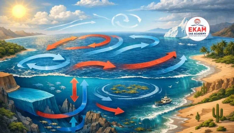
ToggleOcean Currents represent a continuous, directed movement of seawater generated by a complex interplay of forces including wind, the Coriolis effect, and thermohaline variables. They constitute the horizontal flow of a mass of water for great distances.
Factors Influencing the Origin of Ocean Currents
The movement of ocean water is initiated and modified by several primary and secondary forces.
A. Primary Forces (The Initiators)
- Insolation and Heating: Solar energy causes water to expand. Near the Equator, the ocean surface is about 8 cm higher than in middle latitudes. This creates a very slight gradient, causing water to flow poleward.
- Prevailing Winds: This is the most dominant factor for surface currents. Winds like the Trade Winds and Westerlies drag the surface water through friction.
- Coriolis Force: Due to Earth’s rotation, currents are deflected to the right in the Northern Hemisphere and to the left in the Southern Hemisphere. This is known as Ferrel’s Law.
- Gravity: Gravity tends to pull water down the “slope” created by expansion or wind piling.
B. Secondary Forces (The Modifiers)
- Temperature Differences: Cold water is denser than warm water. Denser water sinks, while lighter water rises.
- Salinity Variations: High salinity makes water denser. Water flows from areas of low salinity (lower density) to areas of high salinity (higher density).
- Shape of the Coastline: Landmasses obstruct the flow and redirect currents. For instance, the nose of Brazil divides the Atlantic South Equatorial Current.
Classification of Ocean Currents
Ocean currents are categorized based on their depth and temperature.
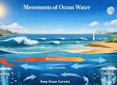
I. Based on Depth
- Surface Currents: Make up about 10% of all the water in the ocean and reside in the upper 400 meters.
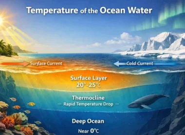
- Deep Water Currents: Make up the remaining 90%. They move around the ocean basins due to variations in density and temperature. This is known as the Thermohaline Circulation.
II. Based on Temperature
- Warm Currents: Flow from low latitudes (tropics) toward high latitudes. They bring warm water to cold regions and are usually found on the east coasts of continents in the mid-latitudes.
- Cold Currents: Flow from high latitudes toward the equator. They bring cold water to warm regions and are usually found on the west coasts of continents.
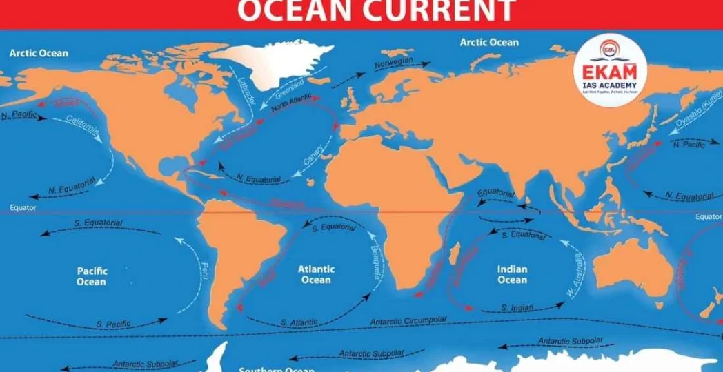
Major Ocean Currents of the World
For the UPSC Prelims, memorizing the location and nature of these currents is essential.
A. The Atlantic Ocean
- Gulf Stream (Warm): One of the strongest currents; it keeps the ports of North-Western Europe (like the UK and Norway) ice-free in winter.
- Canary Current (Cold): Flows along the Western coast of North Africa and contributes to the aridity of the Sahara Desert.
- Labrador Current (Cold): Originates in the Arctic and meets the Gulf Stream near Newfoundland, creating one of the world’s richest fishing grounds but also dangerous fog.
B. The Pacific Ocean
- Kuroshio Current (Warm): The “Gulf Stream of the Pacific,” flowing along the coast of Japan.
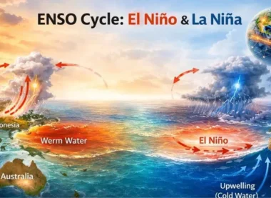
- Humboldt/Peru Current (Cold): Flows along the west coast of South America. Its periodic replacement by warm water is known as the El Niño phenomenon.
- Oyashio Current (Cold): Meets the Kuroshio, creating a prolific environment for Phytoplankton.
C. The Indian Ocean
- The Monsoon Drift: Unique to the Indian Ocean, the direction of these currents reverses twice a year in response to the Seasonal Monsoons.
- Agulhas Current (Warm): A major western boundary current flowing along the east coast of Africa.
The Concept of Ocean Gyres and the Sargasso Sea
A Gyre is a large system of circulating ocean currents. There are five major gyres: North Atlantic, South Atlantic, North Pacific, South Pacific, and Indian Ocean.
- The Sargasso Sea: Located in the North Atlantic, it is a unique region of calm, stagnant water trapped within the North Atlantic Gyre. It is famous for its Sargassum seaweed and for being the only “sea” with no land boundaries.
Climatic and Economic Significance
This section is vital for UPSC Mains answer writing.
- Desert Formation: Cold currents lead to atmospheric stability and “desiccating” (drying) effects. Most tropical deserts (like the Atacama and Namib) are located on the western coasts near cold currents.
- Navigation: Ships often follow currents to save time and fuel.
- Fishing Grounds: The mixing zones of warm and cold currents (e.g., near Japan and Newfoundland) are the world’s most productive fishing grounds due to the abundance of nutrients.
- Heat Balance: Currents act as a “Global Conveyor Belt,” transferring surplus heat from the tropics to the heat-deficient polar regions.
Ocean Currents and Climate Change
Recent data suggests that the Atlantic Meridional Overturning Circulation (AMOC) is weakening due to the melting of Arctic ice.
- The Impact: Fresh water from melting glaciers reduces the salinity and density of northern waters, preventing them from sinking. This could potentially “shut down” the conveyor belt, leading to drastic cooling in Europe and altered rainfall patterns in the tropics.
UPSC Prelims: PYQs & Practice Questions
Previous Year Questions (PYQs)
1. Consider the following factors: (2012)
Q:
1. Rotation of the Earth
2. Air pressure and wind
3. Density of ocean water
4. Revolution of the Earth
Which of the above factors influence the ocean currents?
(a) 1 and 2 only
(b) 1, 2, and 3 only
(c) 1 and 4 only
(d) 2, 3, and 4 only
Answer: (b) 1, 2, and 3 only
Explanation: Rotation creates the Coriolis force which deflects currents. Wind provides the primary driving force for surface currents. Density differences (driven by temperature and salinity) drive deep-water thermohaline circulation. Revolution (Earth’s orbit around the sun) affects seasons but does not directly initiate the movement of ocean water.
2. Which of the following is a cold current? (Generic UPSC Theme)
Q:
(a) Brazil Current
(b) Gulf Stream
(c) Kuroshio Current
(d) Canary Current
Answer: (d) Canary Current
Explanation: The Canary Current flows from the North Atlantic toward the Equator along the coast of Africa, bringing cooler water. The others (Brazil, Gulf Stream, Kuroshio) are all Western Boundary Currents that carry warm water from the tropics toward the poles.
Practice Questions (Prelims)
Question 1
Q: With reference to Upwelling, consider the following statements:
1. It involves the rise of cold, nutrient-rich water from the ocean depths to the surface.
2. It usually occurs on the eastern coasts of continents in tropical regions.
3. It is often inhibited during an El Niño event in the Eastern Pacific.
Which of the statements given above is/are correct?
(a) 1 and 2 only
(b) 1 and 3 only
(c) 3 only
(d) 1, 2, and 3
Answer: (b) 1 and 3 only
Explanation: Upwelling typically occurs on the western coasts of continents (e.g., Peru, California, Namibia) due to offshore winds. Statement 3 is correct because the arrival of warm water during El Niño prevents the colder deep water from rising.
Question 2
Q: The Sargasso Sea is located within which of the following ocean gyres?
(a) North Pacific Gyre
(b) South Atlantic Gyre
(c) North Atlantic Gyre
(d) Indian Ocean Gyre
Answer: (c) North Atlantic Gyre
Explanation: It is a calm region in the North Atlantic trapped by the Gulf Stream, Canary Current, North Atlantic Current, and North Atlantic Equatorial Current, forming the North Atlantic Gyre.
UPSC Mains – Previous Year & Practice Questions
Previous Year Questions (Mains)
Origin of Ocean Currents & Regional Climate (GS Paper I)
Question: “Explain the factors responsible for the origin of ocean currents. How do they influence the regional climate?”
Approach: Categorize factors into primary (Insolation, Wind, Coriolis) and secondary (Salinity, Density). Use the North Atlantic Drift warming Europe as a prime example.
AMOC & Global Climate Risk (General Theme – 2023/24 Context)
Question: “What is the Atlantic Meridional Overturning Circulation (AMOC) and why is its potential collapse a cause for global concern?”
Approach: Define it as a part of the thermohaline circulation. Discuss impacts on European winters and tropical rainfall patterns.
Major Currents of the Indian Ocean & Monsoon Reversal (General Theme)
Question: “Describe the major currents of the Indian Ocean. How does the seasonal reversal of the monsoon affect these currents?”
Approach: Contrast the South-West Monsoon Drift (Summer) with the North-East Monsoon Drift (Winter).
Ocean Currents & Fishing Industry (General Theme)
Question: “How do ocean currents affect the fishing industry? Give examples.”
Approach: Discuss rich fishing grounds at mixing zones of warm and cold currents (e.g., Grand Banks near Newfoundland where Gulf Stream and Labrador Current meet).
Ocean Currents & Tropical Deserts on Western Margins (General Theme)
Question: “Discuss the role of ocean currents in the formation of tropical deserts on the western margins of continents.”
Approach: Link cold currents (e.g., Benguela, Humboldt) to atmospheric stability, desiccation, and lack of convectional rainfall.
Mains Practice Questions
Ekman Spiral: Concept & Significance
Question: “Analyze the concept of the Ekman Spiral and its significance in the movement of surface ocean water.”
Arctic Amplification & Disruption of Global Conveyor Belt
Question: “The Arctic is warming faster than the rest of the planet. Evaluate how Arctic Amplification is disrupting the global conveyor belt of ocean currents.”
Socio-Economic Importance of Western Boundary Currents
Question: “Examine the socio-economic importance of Western Boundary Currents for the nations situated along their paths.”
Ocean Currents: The Global Heat Engine of the Hydrosphere- FAQs
What is the 'Global Conveyor Belt'?
It is a constantly moving system of deep-ocean circulation driven by temperature and salinity (Thermohaline Circulation). It can take over 1,000 years for a single parcel of water to complete the entire circuit.
Why are western boundary currents faster than eastern boundary currents?
This is due to Western Intensification. As the Earth rotates, the Coriolis force causes the water in an ocean gyre to pile up toward the west, forcing the current to narrow and speed up (e.g., the Gulf Stream).
How do ocean currents help in climate regulation?
They act as a planetary thermostat. Warm currents carry excess solar energy from the Equator to the Poles, while cold currents return cold water to the Tropics, preventing the Equator from becoming too hot and the Poles from becoming too cold.
What is the 'Sargasso Sea' and why is it unique?
It is a region in the North Atlantic characterized by very calm winds and thick mats of seaweed called Sargassum. It is unique because it is the only sea in the world with no land boundaries, being defined entirely by ocean currents.
What happens when a warm and cold current meet?
These regions are characterized by:
Thick Fog: Caused by the condensation of moisture when warm air meets cold water.
Rich Fishing Grounds: The mixing stirs up nutrients, promoting the growth of Phytoplankton, the base of the marine food chain.